
OJITO WILDERNESS AREA
BY MICHAEL RICHIE
FROM: "Ojito Badlands—Makin’ Tracks," New Mexico Magazine, Dec. 2000.
AND: “Badlands Gallery,” Albuquerque Journal , Outdoors & Recreation section, June 7, 2001, with 3 color and 1 B&W photos.
AND: “Desert Ratting in the Ojito Wilderness Study Area,” Wild Side, New Mexico’s Outdoor Magazine, Late Fall / Early Winter 2002, with 3 B&W photos.
AND: “Good News Awaits Ojito Badlands,” Around505 , June/July 2005, with 3 color photos.
AND: "7 San Juan Basin Badlands," InsideOutside Magazine, The Durango Herald, June/July 2005, with 7 color photos.
AND: "The Good,the Bad, and the Beautiful- New Mexico's 9 Best Badlands," New Mexico Magazine, Jan. 2007, with 6 color photos.
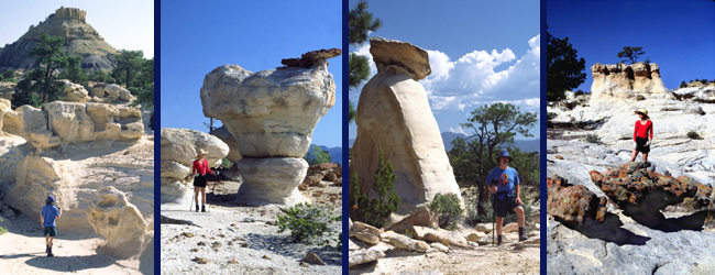
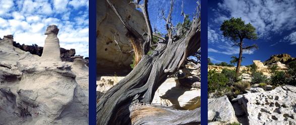
For a confirmed desert rat like me, this little cross-country jaunt across the Ojito badlands is pure delight. I thread my way through a sprawling maze of avant-garde “hoodoo” galleries pausing frequently, absorbed in all the intricate details. Weirdly shaped pinnacles, spires, and fins are sculpted from white, yellow, and tangerine sandstone. They range from massive 40 feet tall spires to tiny mushroom shapes only inches high. Many columns sport bright red cap rocks eroded into such thin, delicately branching shapes that they resemble corral reefs. Others have been worn all the way through by oval windows. Soaring, multi-hued mesas guard these natural sculpture gardens. Their sheer cliffs and banded sides form mineral tinted, rainbow backdrops that even include subtle green, blue, and violet tones.
In some places the gritty rock is fashioned by the elements into sensuous contours. Closely spaced, parallel seams from the original, 80-million year old sand beds have been shaped and burnished with patterns that resemble curving wood grain. Contrasting colored, strangely eroded boulders lay scattered along these smoothly flowing surfaces as if dropped from the sky. In other places the bedrock is curiously pitted and honeycombed with countless bubble-like openings and tiny arches. At times the scene resembles a spooky, otherworldly Sci-Fi movie set. But mostly the badlands evoke the good-natured humor of a Dr. Seuss book.
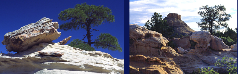
I’ve explored badlands all over the southwest, and while each has a distinctive character, the Ojito formations truly deserve the title “one-of-a-kind.” Evocative shapes and diverse colors are to be expected, but the banzai ponderosa trees come as a real surprise. The stunted, twisted pines growing from barren, solid rock give xeriscaping new meaning. Averaging only 20 feet or so in height, they display the same branching, desert survivor stature as their pinyon and juniper neighbors rather than the tall, straight stance of their mountain relatives. Exceedingly rare at these elevations and somewhat of an ecological mystery, perhaps they are refuges from moister times in the distant past. Maybe tree ring dating would help solve the puzzle, but whatever the answer, they add special character to the ascetic Ojito landscapes. Even their downed skeletons, embellished with a rich patina by sun, wind, and rain, offer poetic testimony to the desert’s harsh reality.
The BLM administered Ojito Wilderness lies about 40 miles northwest from Albuquerque near San Ysidro village. Relatively low elevation, 5500 – 6500 feet, means hot summers but excellent hiking throughout the rest of the year, even winter depending on recent weather conditions. At only 12,000 acres, Ojito may be diminutive as wilderness areas go but still has it all.
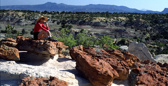
Expansive, 360-degree vistas take in views of the Jemez volcanic peaks, the brilliant red Nacimiento range, cylindrical Cabezon Butte, and the blue-gray silhouette of the Sandias. Cross-country trekking offers a montage of colorful rock sculptures and interesting desert plant life. Picturesque old trees top the list, which includes a very rare cactus and one wildflower, the Townsends aster, found nowhere else on the planet. Wildlife is prolific although the only kinds you will likely encounter are the ubiquitous lizards and the occasional jackrabbit or red-tailed hawk on silent, aerial lunch patrol.
Archeologists have identified some 500 ancient sites with artifacts spanning over 10,000 years of human habitation in the area, including Folsom points shaped by America’s oldest “paleo-Indians”, impressive petroglyphs, and a dozen small Anasazi-style pueblos. Petrified wood abounds in some hoodoo galleries and dinosaur fossils lie exposed in others. Ojitos 15 minutes of fame arrived back in 1985 when New Mexico Natural History Museum paleontologists excavated the fossilized remains from the largest dinosaur yet discovered, the aptly named Seismosaurus.
Ojijo country holds 100% raw, rugged desert terrain with no real trails or water, so actually finding all these attractions can be challenging. The dirt road in gets very muddy after any significant precipitation with precious few signs to provide helpful directions. The access route, called Cabezon Road, branches left off NM 550 about 2 miles south of San Ysidro. Immediately take the smaller left fork, as the right one heads up the hill to a gypsum mine.
The route travels through Zia Indian Pueblo land for several miles to BLM public lands. A small parking lot on the right marks the start of a mountain biking trail through tilted, jagged sedimentary layer castles. The Ojito Wilderness boundary sign is about 2 miles farther up the road. About nine miles in, a “Parking” sign marks the path to the petroglyphs and the Seismosaurus site. The road gets progressively tougher as it skirts the WSA’s southern edge until about 12.5 miles in where it makes a hard right at a small natural gas pumping facility and gets even narrower as it follows the western edge for another 4 miles. You can pull over just about anywhere along the route and head into the outback for excellent cross-country trekking. The best badlands lie in the northwest corner of the WSA but you’ll find entertaining rock forms and strange landscapes scattered throughout the whole WSA.
All Ojito’s scenic and geologic diversity is carved from a mere 600 feet thick section of sedimentary layer cake. The multi-colored sandstone and shale beds formed during the dinosaur age and chronicle the slow expansion of an ancient inland sea. A large meandering river deposited the Morrison formation, Ojito’s oldest and lowest layer, beginning about 144 million years ago during the Jurassic period. In other western states the well-known Morrison formation has produced the most exceptional Jurassic dinosaur fossils in the world, primarily the long-necked, plant eaters known as sauropods. New Mexico seemed left out of the picture until Ojito finally divulged 8 vertebrae and several leg bone fragments from the 120 feet long, 100 ton Seismosaurous that at the time was the largest dinosaur species yet.
The Morrison layers are topped by younger Dakota sandstone formed about 80 million years ago along the shoreline of an encroaching ocean—petrified beaches in other words. While these layers don’t hold many fossils, they sure produce great hoodoo sandcastles. Finally come the Mancos shales laid down beneath deep, offshore water and filled with fossil shells from various marine creatures. Uplift and subsequent erosion have created so many classic geological features in Ojito’s intriguing layered medium that a half dozen major universities from around the country use it as an outdoor teaching laboratory.
Whether your interests are scientific or purely recreational, don’t underestimate this isolated, sun-baked stretch of high desert country. You’ll find no marked trails or surface water—which is fine for a true desert rat like me as that stuff only detracts from the experience. After awhile all those rocks might start looking similar so make a conscious effort to select prominent landmarks for navigation. One helpful trick is to turn around regularly and look back in the direction you plan on returning. Always carry plenty of water, sun protection, and common sense before heading off cross-country. Exploring Ojito’s wide-open spaces will offer ample rewards despite the very real potential for danger.
| HOME |
GEOLOGY |
PHOTOGRAPHY TIPS | RECREATION | MAP - INDIVIDUAL BADLANDS |
| INDIVIDUAL BADLANDS PAGE | PHOTO TOURS |
BADLANDS OVERVIEW |
This site is property of PhotoTrekNM. All rights reserved. Copyright 2007.