
PENISTAJA MESA BADLANDS
BY MICHAEL RICHIE
FROM: “ Mesa Penistaja- Strange Cairns Heighten Badlands Mystery.” New Mexico Magazine , Aug. 2004, with 2 color photos.
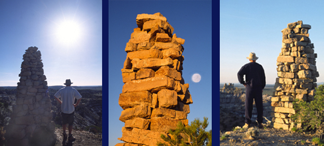
If this were a Sherlock Holmes story it would be titled “The Mystery of the Penistaja Cairns.” Several weeks before, while exploring badlands on BLM land about 25 miles west of Cuba, I spotted a tall, thin column high above on Mesa Penistaja’s precipitous southern edge. Even from a distance the elegant silhouette was immediately compelling. It definitely appeared manmade. So I convinced my hiking partner to climb with me. Once on top we knew we had found something unique.
The beautifully constructed, eight feet high column had a three by four feet rectangular base that gradually tapered up to waist height and then became cylindrical. The flat building stones were obviously carefully selected and fitted in a style reminiscent of the morterless Anasazi stone work found in many ancient pueblo ruins. Significant effort and skill had gone into making this perfectly preserved structure—for what purpose? The cairn commanded an impressive view far south to Cabezon Butte and east to the 90 mile long Nacimiento Range. Was it a marker meant to be seen from afar?
As our excitement and conjecturing increased, I saw two more similarly shaped cairns evenly spaced along a quarter mile section of the mesa edge. Three expertly constructed stone columns atop a high mesa in the middle of nowhere—what could all this mean?
I contacted Gretchen Obenauf, BLM archeologist at the Albuquerque Office and she advised us to locate the three cairns on the appropriate topographic map in order to search for a record of them in archeological data bases.
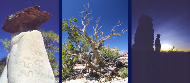
Our second trip only heightened the mystery. We noticed some lichen growing on the columns, particularly on the north side, which suggested that at least they weren’t brand new. After locating the cairns on the map using the middle cairn to get a compass reading on the other two, we found, that despite the extremely rugged terrain, all three cairns fell almost perfectly on a line running northwest to southeast. We also discovered curious pictographs incised onto a nearby hoodoo.
No official record exists at the BLM of these cryptic structures. Knowing who made them would narrow age possibilities and probably give a general clue about their purpose. Ms. Obenauf began contacting colleagues to gather more information and I launched my own investigation. After hearing the general location and description, Dr. Phillips, curator of Archeology at the Maxwell Museum, thought they could be Navajo in origin. I contacted Stephen Begay with the Navajo Historical Preservation Culture Program. Without actually seeing photos, he said Navajo cairns were fairly common in that area and had various uses such as trail or boundary markers or they might be associated with a ceremonial shrine. Ms. Obenauf’s research continues and she is keeping an open mind as to their origin.
Intriguing, cliff top cairns aren’t the only reason for visiting this unique area. Exploring the incredibly diverse Penistaja badlands formations makes a wonderful San Juan Basin outing. Sprawling Penistaja mesa has an extremely complex perimeter surrounded by dozens of equally complicated smaller mesas and buttes. The end result is a highly entertaining formation filled canyon maze and miles of convoluted mesa edges carved into fantastic shaped cliffs hiding numerous hoodoo galleries. Hiking the mesa edges involves a continuous discovery process with views soaring past intricately carved canyon walls out to diverse and scenic landscapes.
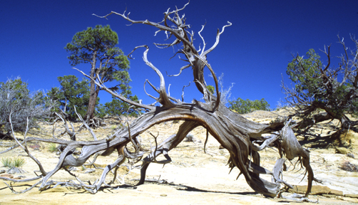
The isolated mesa tops resemble superbly xeriscaped botanical parks showcasing the incredible strength and beauty of New Mexico’s high desert vegetation. Venerable desert survivors, the picturesque junipers and dwarf ponderosa, with their squat branching postures, thick trunks and roots clutching at bare rock speak eloquently about the desert’s unforgiving heart. Their downed skeletons form richly textured, intricate wood sculptures resting on ascetic sandstone bases.
Huge petrified tree trunks litter the canyon bottoms. I’ve encountered fluted bases almost 5 feet in diameter. In places hillsides are covered with various sized broken pieces of petrified wood. Black, carbon rich shale layers throughout the badlands hint at the lush environment that existed 50 million years ago when this area was covered by branching rivers, lakes, and bogs.
I’m back at the cairns for the third time in as many weeks. The setting sun casts a peaceful amber glow and the full moon rises, tracing the column’s tapering length. Views stretch away to far horizons, a gentle evening breeze signals this day’s end. Archeological mysteries, fantastically sculpted badlands, crystal clear vistas— this must be New Mexico.
| HOME |
GEOLOGY |
PHOTOGRAPHY TIPS | RECREATION | MAP - INDIVIDUAL BADLANDS |
| INDIVIDUAL BADLANDS PAGE | PHOTO TOURS |
BADLANDS OVERVIEW |
This site is property of PhotoTrekNM. All rights reserved. Copyright 2007.